Four years ago, our heroic Armed Forces of Ukraine drove the enemy out of Moshchun, putting an end to their ambitions for our capital.
But let’s analyze why four years ago the enemy was within the suburbs of Kyiv in just a few hours.
Today is not about Zelenskyy and the CIA warnings – this topic has already received much attention.
Today we will explore deeper reasons – historical and geographical.
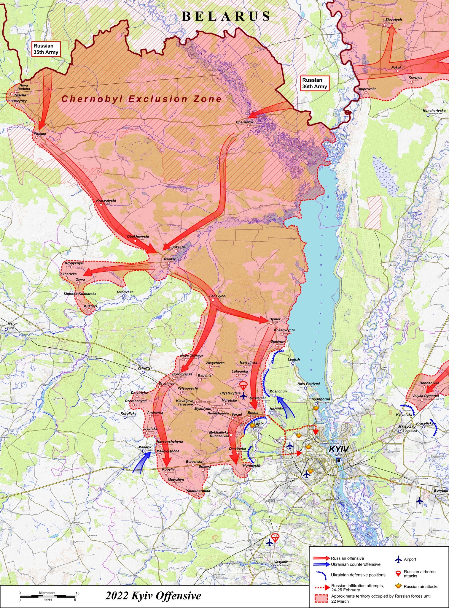
On the map of the invasion of Kyiv region, it is clear that the whiskered fool from Belarus allowed the most dangerous enemy grouping to pass through its territory into Ukraine. Essentially, this cockroach signed that the territory of Belarus does not exist.
Historically, our ancestors did not build Kyiv on the border with the enemy, so they would not wake up one morning to find the enemy in the heart of the state. The Polans founded the city at a geographical point well protected from all sides. From the east (the main threat), the capital is shielded by the massive current of the Dnipro. From the south – the same Dnipro flows down for hundreds of kilometers, but closer by the Stuhna River, and further south by the Ros River, along which Prince Volodymyr built defensive ramparts. And from the north, which interests us most now, the capital of Rus’ was reliably protected by four whole water barriers: the Irpin, the Teterev, the Uzh and the mighty Pripyat rivers.
It was at the Irpin that the Russian army was stopped in 2022.
But the northernmost water barrier, the Pripyat, and the Polesian marshes – this is a mass of impassable, impossible-to-surmount obstacles. They are easier to bypass by hundreds of kilometers than to overcome head-on.
That is why, for example, in 1941, the German command during Operation Barbarossa realized this: Army Group Center advanced eastward north of the Polissya line, and Army Group South to the south.
In 1944, Soviet generals understood the same: the dividing line between the 1st Belorussian and the 1st Ukrainian Fronts during Operation Bagration passed exactly along the same line of the Prypiat River. The 1st Ukrainian Front advanced southward and did not cross the dividing line, while the 1st Belorussian stayed north and never “moved” south.
Both commands clearly grasped the military and geographical significance of the Prypiat River in their strategy. They did not consider the real official borders of the BSSR and USSR, but were forced to take into account the geographical component.
2000 years ago, our ancestors considered this as well.
The map of the spread of ancient settlements from the 6th-12th centuries by archaeologist M.P. Kuchera shows that the Ukrainian people (Rus, Slavs) formed in the basin of the Prypiat, middle Dnipro, Desna, and Ros rivers. Plus, allied groups of tribes from the Dniester basin, the Carpathian and Transcarpathian zones, as well as the Siverskyi Donets and Don.
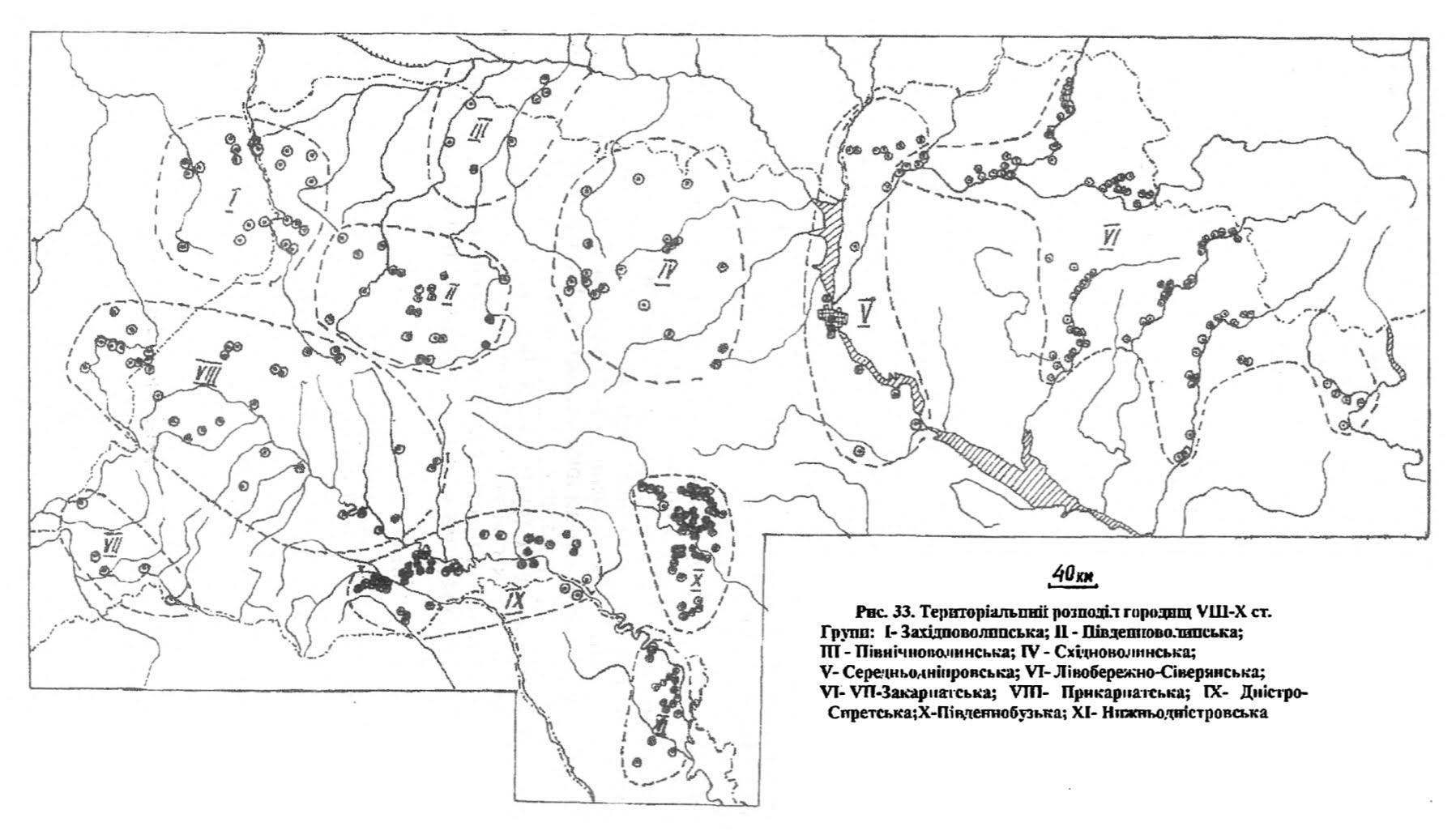
“Rus” tribes, whom Kyiv chroniclers consider “their own,” include the Volhynians, Drevlians, Dregovichs, and Polans, forming Rus and later becoming Ukrainians. They live on this side of the Prypiat. These are conventionally “our” tribes. And to the north of the Prypiat are different, non-native tribes like the Yatvingians.
That is, the Prypiat River and the Polissya marshes were a border between civilizations.
A recent study by an international group of scientists published in the journal Nature about the origin of the Slavs confirms this picture: the Slavs formed in this natural zone. It is here, in Northern Ukraine and Southern Belarus (up to the Prypiat), that the ethnic core of not only Ukrainians but also Slavs is located.
Our ancestors settled here and managed to develop successfully because the Pripyat River, as a tributary of the Dnieper, had several well-developed navigable tributaries at the time. Contrary to the notion of “sedentary farmers,” in the absence of roads, the presence of developed waterways allowed our ancestors to be mobile. The Volhynians could easily reach the Pripyat via the Horyn (Styr, Sluch), gathering together with the Drevlians along the way. They would then enter the Dnieper from the Pripyat, joined by the Severians from the Desna. The hypothetical Drevlians from Zhytomyr would follow a “parallel” route along the Teteriv and under Kyiv, where they would all merge into a united community. It was here they met the Polans, who had established their Kyiv base right at the confluence of all these rivers. Further, as Constantine Porphyrogenitus notes, the Rus together would overcome the Dnieper rapids and embark on trading expeditions as far as Byzantium. * Ibn Khordadbeh mentions trading missions of the Slavs reaching Baghdad.
In fact, the defense against the southern “operational direction”—the nomadic hordes of the Steppe—was the main concern for the ancestors of Ukrainians. From the north, our civilization was securely protected from any neighbors. It was a closed zone, and no enemy could overcome the Pripyat. Even if they did, they would have to cross the Uzh, Teteriv, and Irpin before approaching Kyiv.
This scenario continued during the times of Rus and lasted until the 19th century.
For example, the capital of the Dregovichians, the city of Turaŭ, located directly on the Pripyat (currently in Belarus), is situated precisely on the Polesian dividing line. From the 10th century, Turaŭ (named after the Dregovichian prince Tur) became a principality of the Kiev princes of the House of Iziaslav of Turaŭ. In the 14th century, Turaŭ is mentioned in the list of Rus’ cities as a “Kyiv” city. In the 15th-16th centuries, Turaŭ was owned by the most prominent Ukrainian princes of the time, the Ostrozhskis. During Bohdan Khmelnytsky’s era, Turaŭ became part of the Pinsk-Turaŭ Regiment of the Hetmanate. In the autumn of 1648, a popular uprising in support of the national liberation struggle led by Khmelnytsky took place in Pinsk. This indicates that the local population in the 17th century identified with Ukraine, not Lithuania.
In 1793, the former lands of the Dregovichians—Turaŭ and Pinsk—were annexed by the Moscow government to the Mozyr district of the Minsk governorate.
However, during the time of the Ukrainian People’s Republic, the Ukrainian ethnic territories up to the Pripyat River were reabsorbed into Ukrainian civilization. Thus, Pinsk, Turaŭ, Brest, the northern areas of the Volhynians, the Drevlians, and all the land of the Dregovichians were integrated into the Ukrainian People’s Republic. The UNR established a high-level administrative-territorial unit here, calling it the “Land of the Dregovichians.” It was founded on March 6, 1918, according to the “Law on the Administrative-Territorial Division of Ukraine,” passed by the Ukrainian Central Council. It was formed from the Mozyr, Rechytsia, and Homel districts, which remained part of Ukraine until January 1919. The division into lands was abolished on April 29, 1918, by the Ukrainian Hetman Pavlo Skoropadsky, who reinstated the old provincial division from the times of the Russian Empire. In early June 1918, instead of the Land of the Dregovichians, the Polesia District was established, including the Rechytsia, Mozyr, and Pinsk districts, while the Homel district was transferred to the Chernihiv province.
In essence, the purpose of all these administrative actions was to ensure that the entire flow of the Pripyat River was part of the Ukrainian State.
This scene was interrupted only by the next Moscow-Polish aggression and the division of Ukrainian lands.
But even outside the Ukrainian state in the 19th-20th centuries, the territory of Polissia up to the Pripet River actively participated in the Ukrainian national cause. In Brest, Turov, Pinsk, the Ukrainian “Prosvita” was active, and the population published Ukrainian magazines and newspapers, raised funds for monuments to T. Shevchenko, and Ukrainian insurgents operated here. The UPA was active in southern Belarus (Brest, Pinsk, Polissia regions) until 1942-1953, with support from the local population. In the summer of 1944, up to 14,000 insurgents operated here. Belarusians often joined the ranks of the UPA, and the Soviet authorities were forced to conduct large-scale special operations, including village deportations, to fight the insurgents.
The linguistic border between Ukrainians and Belarusians still runs along the Pripet River. This is the so-called Polissian demarcation line.
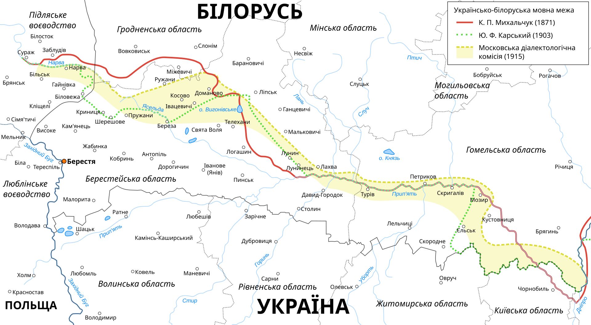
As scientists believe, it was formed in the middle of the 1st millennium BC, when the Balto-Slavic community was dividing into Balts and Slavs, between whom a linguistic and ethnic demarcation gradually formed approximately along the Pripet River and its left tributary Yaselda. South of the Polissian demarcation line lived Slavs, and to the north — Balts, who from the 4th-6th centuries to the 10th century became Slavicized. With some territorial changes from the 4th century AD, it became the Ukrainian-Belarusian linguistic and ethnic border.
Present
And how did it happen that the Russian 35th and 36th armies were already on our side of the defensive line, which for millennia served the ancestors of Ukrainians, in the first minute of the invasion?
This is how it happened.
At the dawn of the Soviet empire, J. Stalin did not start as the leader of nations but as the people’s commissar for nationalities. From 1917 to 1923, he studied the national issue well, with the main focus in the empire being the Ukrainian national question. He understood everything written above.
Therefore, when Moscow again solidified its power over the seized territories, it acted not only through famines in destroying Ukrainian identity but also through “divide and conquer.”
And 100 years ago, the occupiers divided the Ukrainian ethnic map:
1. The capital of the Cossack army, Yekaterinodar, founded by Ataman Anton Golovaty, was renamed Krasnodar, and the Kuban People’s Republic, where Ukrainians in the 1920s wanted to unite with the Ukrainian People’s Republic, was executed, genocided, starved, and settled with Muscovites.
2. The Don Cossacks at the mouth of the Don, with the capital Cherkassk, were founded in the 16th century by the Ukrainian prince Dmytro Vyshnevetskyi from the central Ukrainian Cossacks (Cherkassy). At the turn of the 17th-18th centuries, Moscow, thanks to an alliance with Ukraine, first reached the Sea of Azov, where Taganrog, the first Black Sea port in Moscow’s history, was built by Ukrainians. In 1924, the Ukrainian city of Taganrog was part of the Ukrainian SSR. According to the 1926 census, Ukrainians made up 71.5% of Taganrog’s population and district. Thus, the Moscow civilization crushed the Don Cossacks in an embrace, reached the Don and crossed it in its lower reaches. In 1924, the Moscow Bolsheviks decided to transfer Taganrog to the RSFSR. Thus, the Moscow military command received a bridgehead on the right bank of the Don. This was used by the Russian army in 2014 when Girkin crossed our border from Rostov-on-Don. More details: here and here.
3. The basin of the lower Dniester in the 1920s was similarly torn away from Ukraine by the communists, and on the left bank they created from Ukrainians the imaginary “Moldavian Autonomous SSR” (not to be confused with the Moldavian SSR on the right bank). More details: here and here.
4. The Chernihiv principality and the Cossack Sloboda Ukraine were divided and partially incorporated into the Moscow Ulus.
5. The lands of Galicia and Transcarpathia were “ceded” by Moscow to Poland and Hungary.
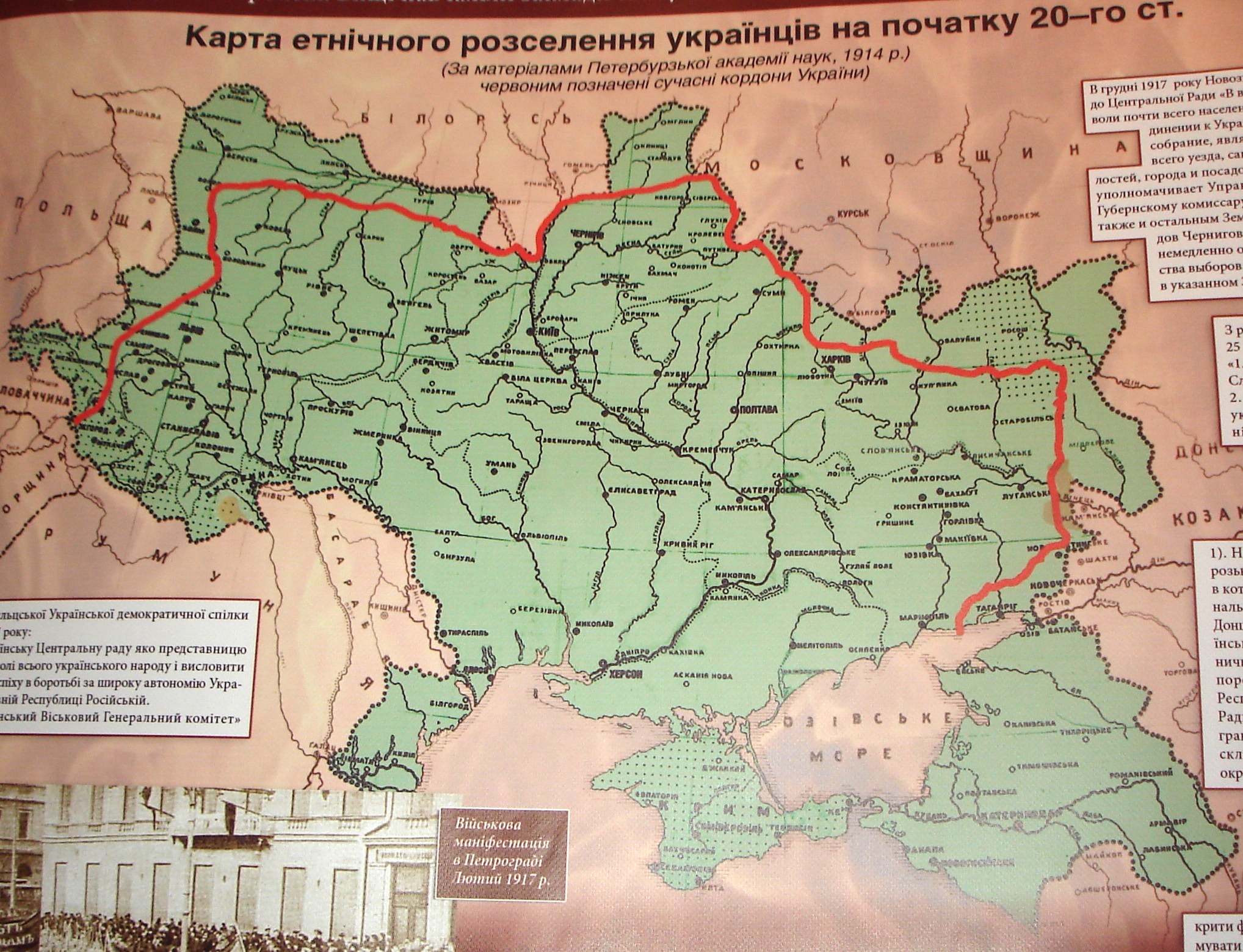
6. Finally, Moscow divided the core of Ukrainian identity—former Volhynians, Drevlians, Dregoviches, and Polans—into three parts: the western part of the lands was given to Poland, the northern (up to the Pripyat) was attached to the Byelorussian SSR, and only the southeastern part was attached to the Ukrainian SSR.
This is how the northern part of the area of Ukrainian emergence ceased to be Ukrainian. And now it is possible to claim that Slavs formed not only on the territory of Ukraine but also in Belarus.
Moscow handed over Polissya to its Belarusian federal district exclusively within the framework of the military objective – the destruction and subjugation of Ukrainian identity.
On one hand, they weakened Ukrainian patriotism and physically reduced the number of patriotic population (in Brest, for example, 100 years ago, Ukrainian newspapers were published, and the population organized into Ukrainian ethnic unions). On the other hand, the Russian tribe thus forced the Pripyat River.
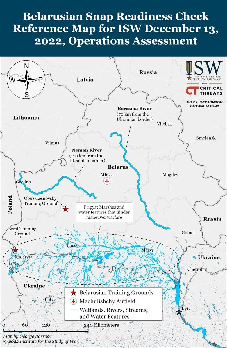
Moscow generals no longer needed to overcome the impassable Polesian defensive line. The map of the Pripyat swamps shows that they begin in the current territory of Belarus and descend south approximately to the borders of Ukraine. Thus, even in the pre-war period, the Muscovites had the opportunity to accumulate unhindered on the bridgehead “on this side” of the Pripyat.
Russian Invasion
It was precisely this fact that allowed the Russian army in 2022 to reach the approaches to Kyiv even before the attack.
On February 24, 2022, Russian troops crossed the Ukrainian-Belarusian border in two places: in the area of Chernobyl and in the area of Nova Radcha in Zhytomyr region. Two Russian armies crossed the border: the 35th and 36th.
But first, they bypassed the impassable Pripyat without a fight.
This is what made the attack unexpected.
Instead of sequentially fighting to force the Pripyat, Uzh, Teteriv, Irpin, the Russians immediately attacked the suburbs of Kyiv.
Just remember how many times orcs in Luhansk tried to cross the Siverskyi Donets, but a single Ukrainian 30th mechanized brigade destroyed 100 units of enemy equipment and 400 orcs in just 2 days near Bilohorivka.
Meanwhile, the width of the Siverskyi Donets at the place where the Russian army failed to cross it is only 30 meters. The width of the Uzh in the north of Kyiv region, where the 36th army crossed it in an hour, is 60 meters. The Teteriv near Ivankiv is 45 meters. Well, the Pripyat at the bridge in the Chernobyl area is a full 230 meters.
However, two Russian armies instantly overcame all these difficult water barriers.
And then the main battles for the Kyiv region took place on the left bank of the last river obstacle – the Irpin River – from Demydiv and the Kozarovychi dam to Moschun, Hostomel, Bucha, Irpin.
But here the width of the Irpin River in the Moschun area, where the orcs threw three pontoon crossings, is only 10-15 meters.
On March 8, the Ukrainian Defense Forces blew up part of the Kozarovychi dam to force the flow of water from the Kyiv reservoir to descend into the Irpin, against the river’s flow, creating a natural barrier, effectively limiting Russian troops’ access to Moschun in the area of the Antonov airport, which they viewed as a gateway to Kyiv. The water level in the Irpin rose by 1.5–2 meters, complicating the crossing of the river.
The Armed Forces of Ukraine retook Moschun, and “it became evident: we won the battle for Kyiv” (Syrskyi).
Honor and glory to all who fought for Moschun.
All these battles might not have taken place in the suburbs of Kyiv if we had built the defense of the capital further north – along the Teteriv, Uzh. Even better – along the Pripyat. On the territory of Belarus.
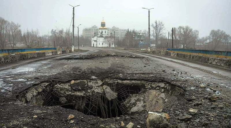
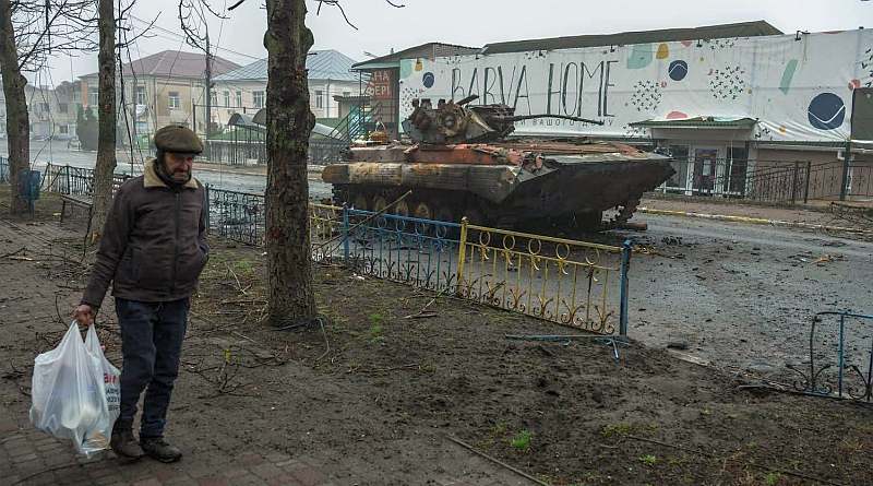
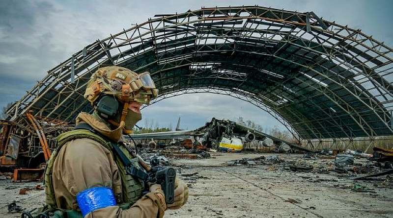
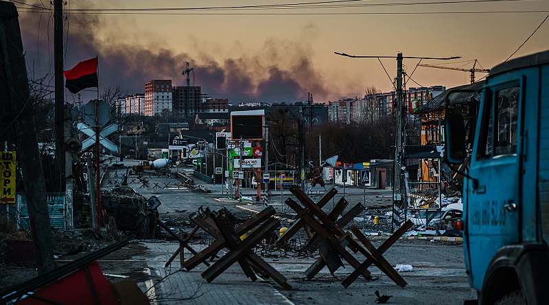
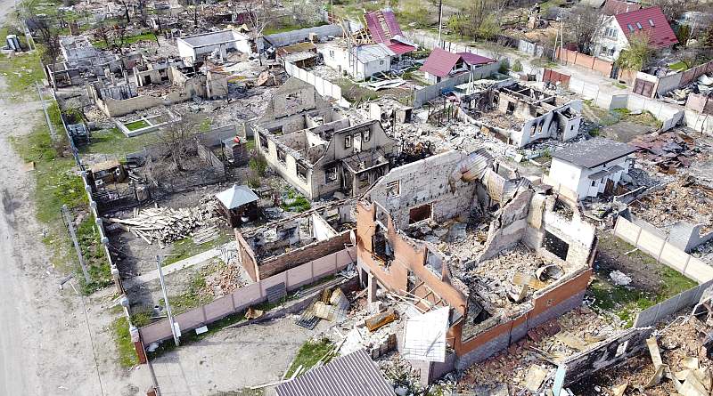
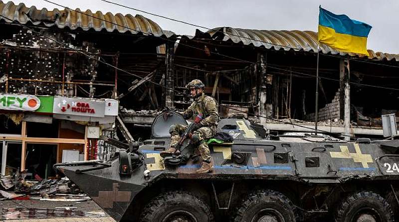
Photos from open sources from March-April 2022.